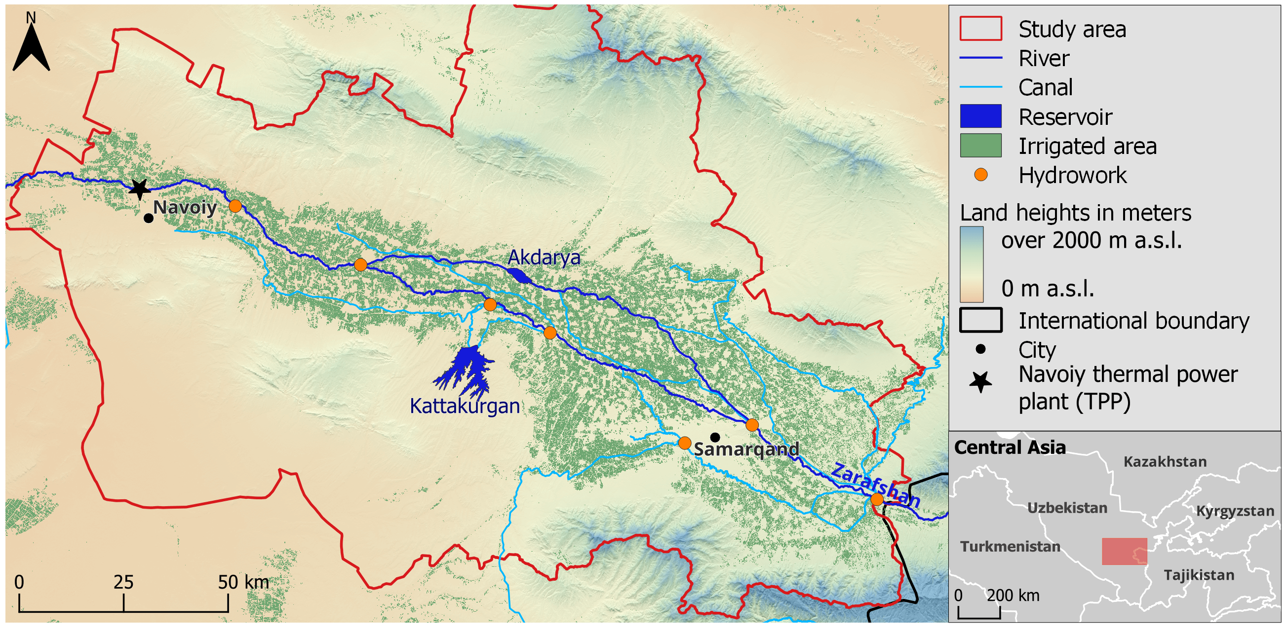
hydrosolutions GmbH developed a water management model to support basin planning in the Samarkand Oasis of Uzbekistan (Figure 1). The new model evaluates the impacts of climate change and land use changes on future water availability under optimal water allocation strategies. The application of the modular and flexible tool is not limited to the Zarafshan River basin, as it can be adapted for application in other water-stressed regions around the world.
Context & Water Management Challenges
The Zarafshan River basin (ZRB) in Central Asia represents one of the world's most water-stressed regions. Runoff formation from snow and glacier melt occurs in the upper part of the ZRB in Tajikistan, contributing over 97% of the river’s total flow. The lower part of the basin lies in Uzbekistan, where most of the water is used for irrigated agriculture and industrial activities. The complex transboundary water dynamics, aging infrastructure, and competing demands pose significant management challenges. As a result, optimal water allocation has become critical for ensuring regional sustainability.
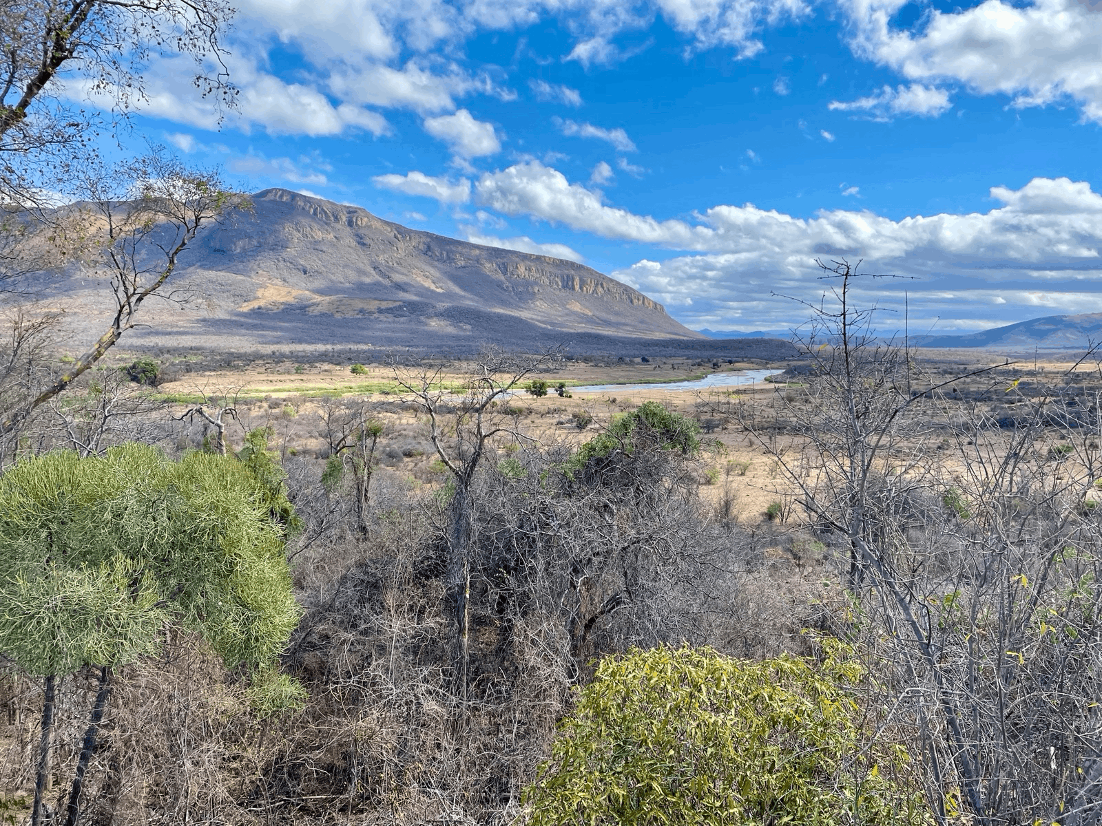
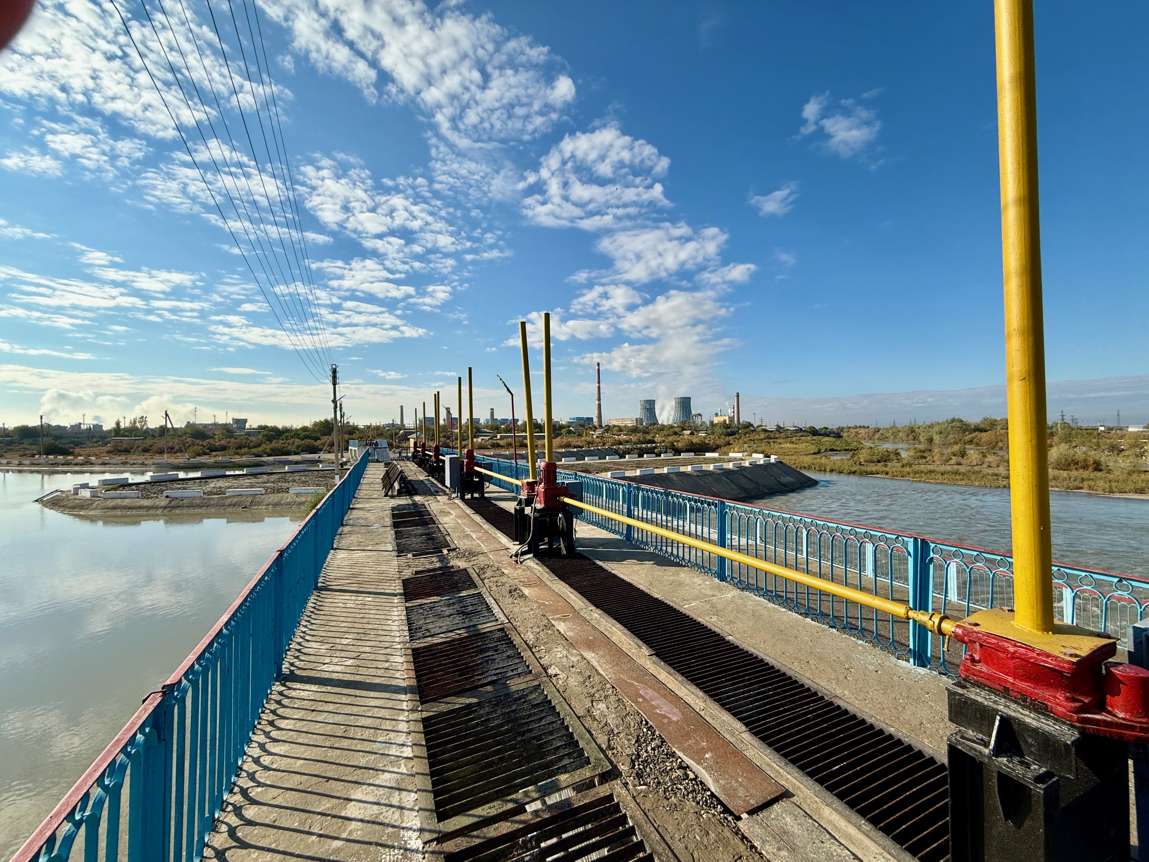
In the Samarkand Oasis, a complex irrigation and drainage canal network, together with many hydraulic structures (Hydroworks), distributes water from the Zarafshan River to various users. At the Hydroworks, decisions must be made regarding how much of the river’s water is directed to each region, and consequently, to each specific water user in the downstream. Additionally, two reservoirs (Kattakurgan and Akdarya) are available to store water and release it during periods of high demand. Even under current conditions, this decision-making process is highly challenging due to the limited availability of water resources, difficulties in accessing reliable data, and competing demands among industrial users (Figure 2), irrigation districts (Figure 3), and environmental flow requirements. In a recent publication, we have shown that current irrigation withdrawals from the ZRB already exceed the available river water supply, resulting in a heavy reliance on energy-intensive pumped irrigation and a significant groundwater overdraft in the Bukhara Oasis that lies further downstream.
Climate change and future development pose significant risks to the current water distribution system of the Samarkand Oasis. Seasonal flow patterns are projected to shift, and discharge variability is expected to increase. To effectively adapt and build resilience to these changes, comprehensive and sophisticated basin planning is essential. This planning should account for various regional development scenarios, such as differing land use strategies, under a range of future socioeconomic and climate scenarios, such as those based on the Shared Socio-economic Pathways (SSPs).
.png)
Our Solution: TaqSim
To support basin planning in the Samarkand Oasis, hydrosolutions GmbH developed TaqSim, a flexible, Python-based water allocation model. It is specifically designed to address the challenges of data-scarce environments and manage complex, multi-stakeholder water systems. The name TaqSim is derived from the Persian word for "partitioning" or"dividing."
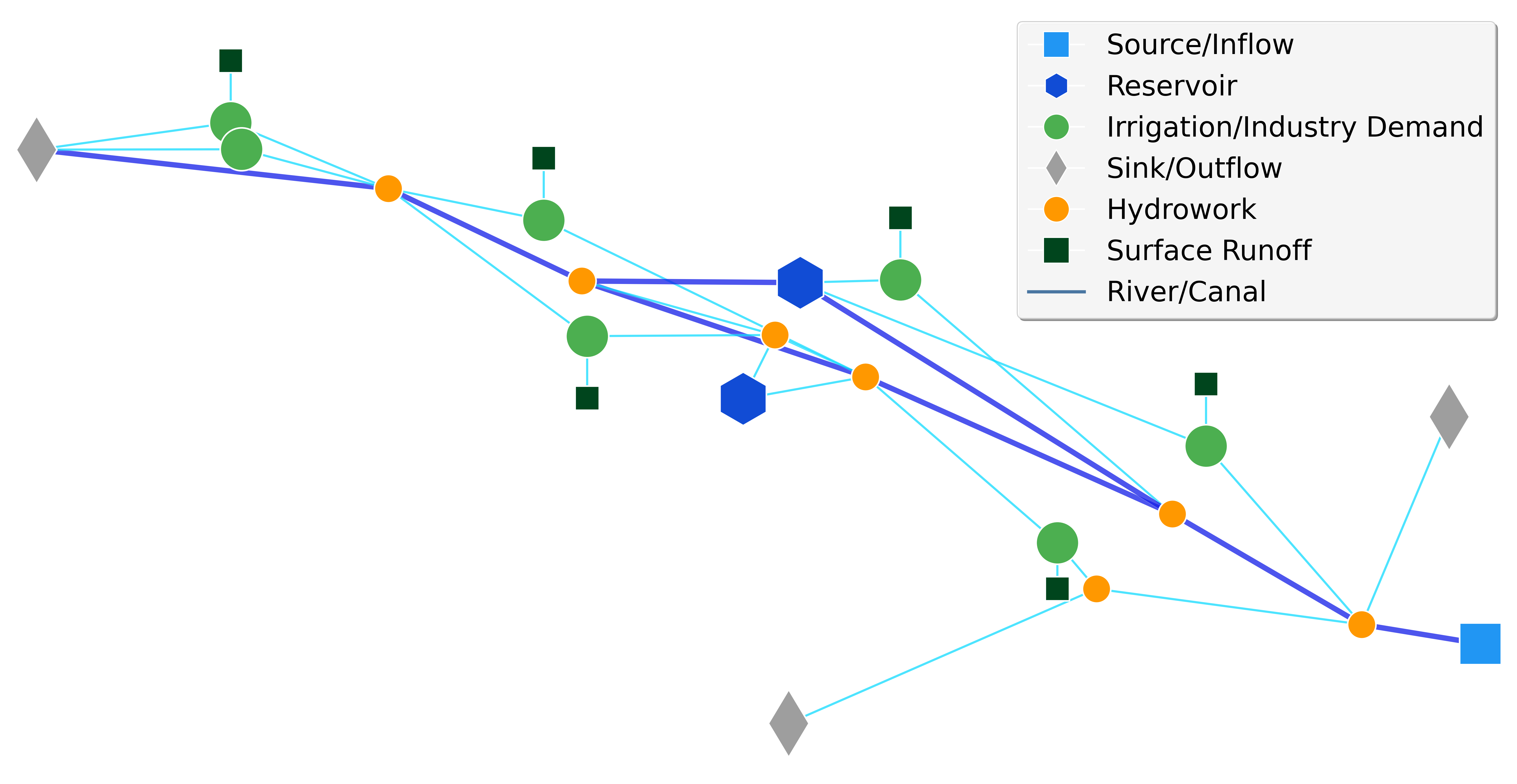
TaqSim features a network-based architecture built on the Python package NetworkX, offering an intuitive representation of water system topology through directed graphs that mirror real-world infrastructure. The model utilises six specialised node types(Source/Inflow, Reservoir, Hydrowork, Demand, Surface Runoff, and Sink/Outflow)to capture the full complexity of water distribution systems. At its core, TaqSim uses an advanced optimisation algorithm based on genetic programming, enabling robust multi-objective optimisation. This allows the model to balance competing demands and tailor objective functions to prioritise specific water users and environmental flow requirements.
TaqSim ensures a comprehensive water balance through monthly time-step modelling, incorporating full mass balance accounting. It explicitly accounts for evaporation losses over reservoirs, conveyance efficiency, and various system constraints. Figure 4 illustrates a TaqSim model of the study area within the Zarafshan River Basin (ZRB). Several structures depicted in Figure 1, such as hydroworks, canals, and reservoirs, are also represented in this model. The Source/Inflow node marks the river's entry point into the system, while the Sink/Outflow nodes represent rivers or canals that exit the defined study area. Demand nodes, shown in light green, represent various water users, including those from agriculture and industry. Additionally, surface runoff from precipitation can be incorporated into the model using dedicated Surface Runoff nodes.
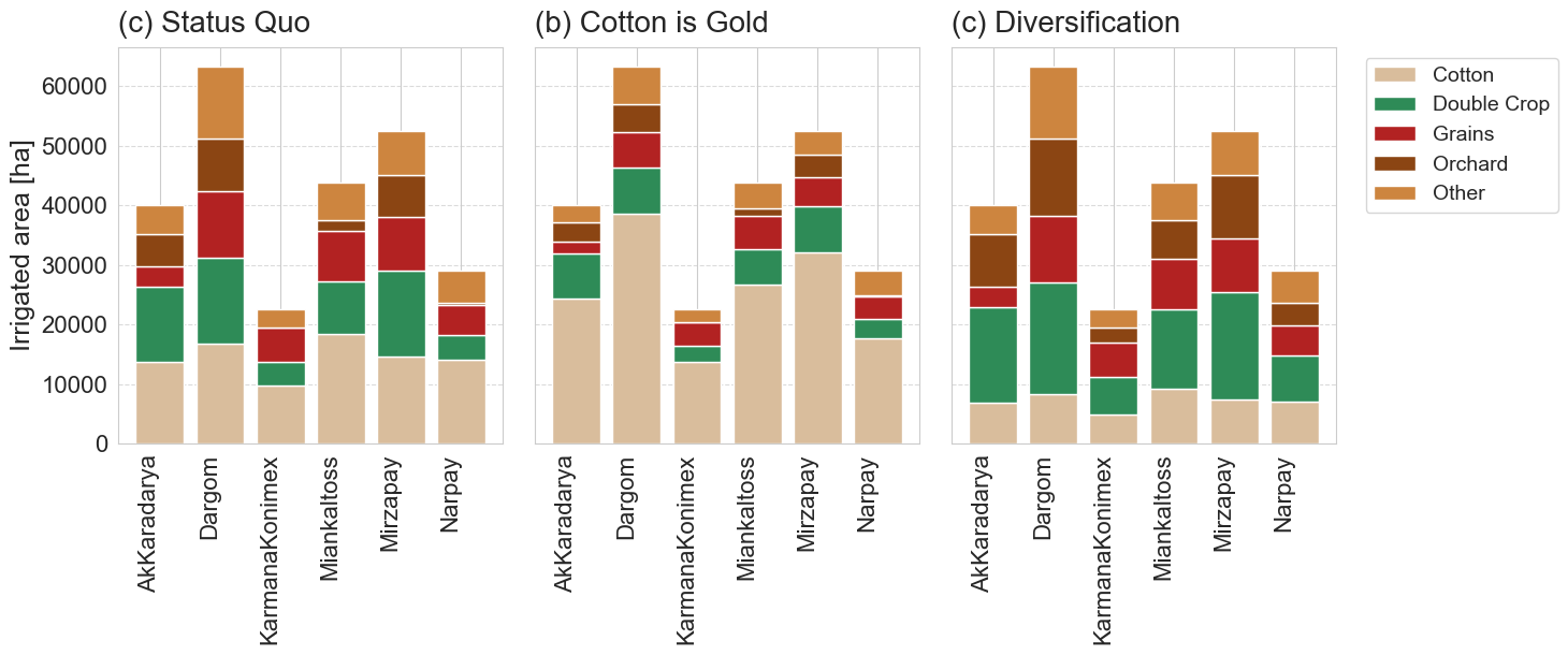
The model can be used to optimise water allocation under various future scenarios, considering different SSPs. These pathways lead to changes in river discharge, precipitation input, reservoir evaporation, and crop water requirements. The model also incorporates different land use strategies, such as a shift from cotton cultivation to more diversified crop production. Figure 5 illustrates possible future land use strategies, the impacts of which on regional water scarcity can be assessed using the TaqSim model.
Multi-Objective Optimisation & Trade-offs
TaqSim helps balance competing water demands by revealing trade-offs through multi-objective optimisation. It identifies Pareto-optimal solutions—outcomes where improving one goal means compromising another—allowing stakeholders to visualise and weigh their options.
The model can optimise up to four objectives, such as reducing water shortages for different user groups or preserving ecological flows in rivers and canals. Additional factors like costs and benefits can be included when data is available. For simpler cases or clear priorities, single-objective optimisation is also supported. TaqSim’s flexible setup adapts to the needs of diverse decision-making contexts.
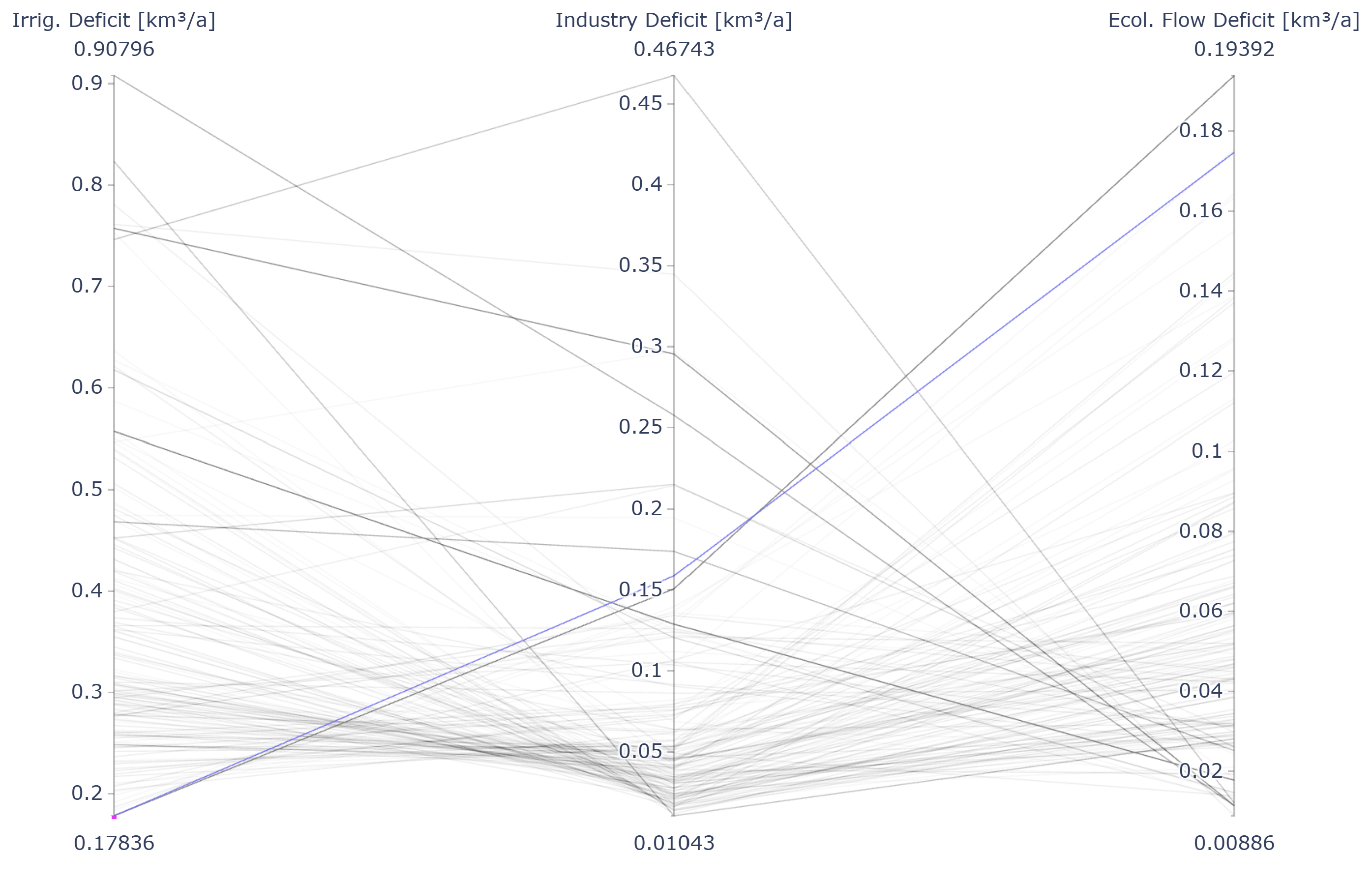
Figure 6 shows all Pareto-optimal solutions from a three-objective optimisation for theZRB, with the objectives being: i) minimising irrigation supply deficit, ii) minimising industrial supply deficit, and iii) minimising ecological flow requirement deficit. Lower water deficits (in km³/year) indicate better performance. The figure illustrates that none of the solutions achieve a deficit of 0 km³/year, underscoring the significant water scarcity challenges faced in the ZRB region. The solution highlighted in blue represents one of the Pareto-optimal solutions with the lowest Irrigation Supply Deficit. However, achieving this minimum comes at the cost of a relatively high Industry Supply Deficit and Ecological Flow Deficit, indicating that minimising one objective entails a trade-off with the others. This illustrates the inherent conflict among competing objectives, a typical feature in multi-objective optimisation problems.
Impact & Applications
TaqSim provides water managers and policy makers with a transparent tool to quantify trade-offs between different user groups and management objectives. It supports climate adaptation planning for long-term water security and facilitates stakeholder negotiations through objective, data-driven analysis. Additionally, the model can be used to assess the impact of various infrastructure measures, such as increasing storage capacities or enhancing canal and river conveyance through the reduction of unproductive losses.
TaqSim features a scalable architecture with a modular design, making it adaptable for application in other water-stressed basins beyond the Zarafshan River basin. Its modular structure allows users to configure models by flexibly combining different node and edge types to represent the specific components of a water system. TaqSim offers a robust, freely available tool for sustainable water resource planning in an increasingly water-constrained world.