We present the SnowMapper CA tool, developed to enhance operational snow cover monitoring and analysis in Central Asia's mountainous regions. This web-based tool leverages ECMWF's ERA5T data and the downscaling pipeline TopoPyScale, for high-resolution snow cover dynamics analysis. The SnowMapper CA provides detailed daily snow height and water equivalent outputs at a 500-meter resolution. It also features a 24-year snow climatology for comparing current conditions with historical data, aiding real-time water resource management. The tool's accuracy compares favorably to data from traditional meteorological stations, and its future enhancements, including a 15-day forecast capability and improved resolution, emphasize its potential to transform hydrological forecasting in Central Asia.
monitored in Central Asoa, including those from Afghanistan
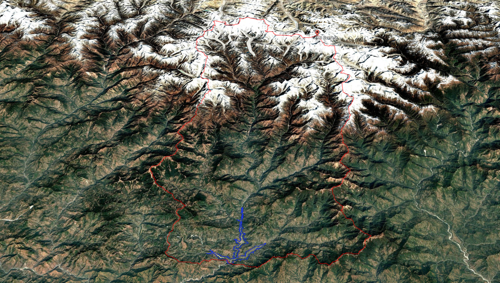
high mountain area covered
daily snow climatology available
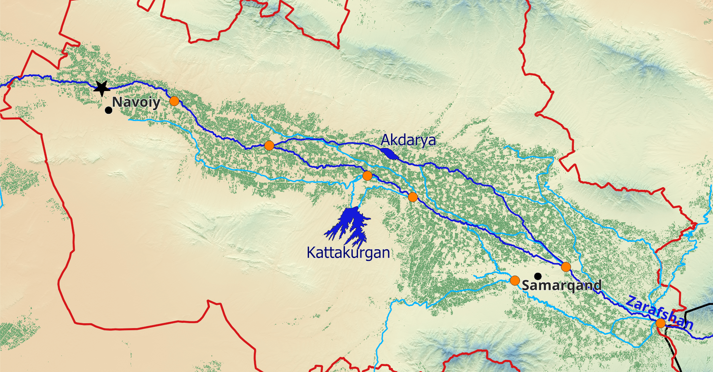
Snow water equivalent anomaly at the end of Feb. 2024 in Amu Darya
The Operational SnowMapper Central Asia
The Swiss Agency for Development and Cooperation supports a range of projects in semi-arid Central Asia that focus on helping the countries in the region manage transboundary water resources effectively. Two of these projects, SAPPHIRE Central Asia and CROMO-ADAPT, have recently collaborated to implement a web-based tool, called SnowMapper CA, to analyze the state of the snow cover across the vast and remote Tien Shan, Gissar-Alay, Pamir, and Hindukush Mountain ranges. Figure 1 shows a screenshot of the tool.

The SnowMapper CA represents a significant leap forward in our ability to quantify and analyze daily snowcover dynamics at a high resolution for mountainous Central Asia. Leveraging the ECMWF's ERA5T global atmospheric reanalysis data with a modest five-day latency, the SnowMapperCA employs a sophisticated downscaling approach via the TopoPyScale pipeline to refine our understanding of the snow distribution. This is of great relevance as snow melt is the dominating runoff-generating mechanism in the region.
At the heart of SnowMapper CA's analytical capability is the Factorial Snow Model (FSM), a physically based snow model enhanced with the spatial mapping capabilities of TopoPyScale. This combination enables the SnowMapper CA to regionalize snowpack simulations, producing daily outputs of snow height in meters and snow water equivalent in millimeters. The 500-meter resolution output notably includes adjustments for the intricate effects of topography on both surface energy and mass balances, which are critical factors in accurately modeling snowpack dynamics.
To provide a robust context for the current observations, the SnowMapper CA constructs a 24-year snow climatology spanning from September 1999 to August 2023. It utilizes the 5th, 50th, and 95th quantiles to delineate the long-term snow distribution, allowing for an immediate comparison of current snow conditions against historical averages. This comparison is pivotal for assessing the current state of snow-based water resources in near real-time across extensive areas.
The SnowMapper CA's results are presented at two scales of hydrological relevance: the "basin" and"sub-basin" levels. This dual-resolution approach ensures that the data is not only relevant for broad-scale hydro-climatological assessments but also at the scale relevant for localized, basin-specific water resource management, offering a nuanced view of the snowpack's current state across different spatial dimensions. For this purpose, data are analyzed for 295 sub-basins using a new dataset developed by hydrosolutions GmbH and covering parts of Afghanistan, Kazakhstan, Kyrgyzstan, Tajikistan, Turkmenistan, and Uzbekistan.
Putting the SnowMapper to Test
The Central Asian National Meteorological and Hydrological Services (CA-NMHS) regularly monitor precipitation accumulation during the cold season. This is based on ten-day precipitation data measured at meteorological stations, which are mostly located between 1’200 meters above sea level (m asl) and 2’100 m asl. Only a very small number of meteorological stations are located above this elevation over a domain that covers more than 400’000 km2, including the territory of Afghanistan. In other words, very little information exists at higher elevations about the accumulation of precipitation and snowpack dynamics.
Table 1 shows the CA-NMHS precipitation surveys for the 2023/24 cold season, which are compared with SnowMapper CA data. The comparison is carried out for the key basins in the domain for which we could obtain local information over the period of interest. In relation to the in-situ data, we assume that all precipitation accumulates as snow over this period and that mass loss due to melt is insignificant.

Generally, the modeled snow water equivalent data compares favorably with the in-situ station data. However, it is important to remember when interpreting this comparison that the in-situ data are derived from a few point measurements over a limited altitude range. In contrast, the SWE anomaly data are sub-basin area-averaged values that integrate information from all altitude zones. Additionally, observed precipitation anomalies are not necessarily equal to SWE anomalies, as the former only assesses drought conditions. In contrast, SWE anomalies result from accumulation and ablation. They can be caused by both unusually dry and/or warm winters, where a greater proportion of precipitation falls as rain.
The SnowMapper CA tool produces daily raster data on snow water equivalent and snow height. These data will soon be made available via the SAPPHIRE Central Asia Data Gateway for later processing and use in hydrological forecasting models in the CA-NMHS. Stay tuned for more information.
Outlook
In a future release, we will also utilize the recently released open IFS forecast data from ECMWF to fill the 5-day latency of the ERA5T reanalysis dataset and provide a 15-day forecast of the snowpack evolution. We will also increase the model resolution to 100 meters to better represent slope-scale processes. Lastly, we intend to plug in FSM-modelled past and future snowmelt as a predictor of our machine-learning discharge forecasting models to assess the value of snow information in forecasting.
We are confident that the SnowMapper CA will become an indispensable tool for operational hydrologists in the CA-NMHS and help to revolutionize hydrological forecasting in these institutions.